National Trails Day: 8 Trails Less Traveled
Avoid crowded trailheads this weekend with these hike recommendations
June 6 is National Trails Day, and we want to take the opportunity to share our favorite trails less traveled. We’ve compiled favorite trails from eight staff members to give you some ideas about where to explore this weekend and throughout the summer.
If you’re looking for even more great trails, explore our new and improved online hiking guide. Hike Wild Montana features more than 350 trails across the state, providing options that will help you stay safe, avoid crowded trails and trailheads, and discover some of Montana’s lesser-known gems.
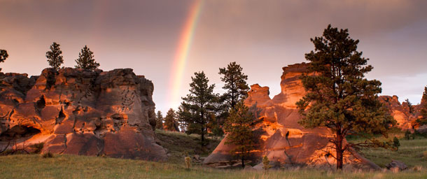
A short walk among the unique sandstone towers at this holy place sacred to the Indigenous peoples of the Great Plains (photo by Dee Linnell Blank)
Medicine Rocks State Park (south of Baker)
Medicine Rocks is my favorite state park. It’s a few miles south of Baker, a few miles north of Ekalaka, and basically a stone’s throw from South Dakota: it’s about as far east as you can get in Montana. The park is relatively small, just 330 acres, but has 12 developed campsites, including a group site, to choose from.
It’s named for the medicine rocks – large hunks of sandstone that dot the area and have been eroded into swiss cheese-like formations by millions of years of wind and water whipping across the prairie. Great Plains Nations used this area as a meeting spot for diplomatic talks, hunting parties, and other ceremonies. In the late 1800s, Teddy Roosevelt was also entranced by the rocks, calling the area “As fantastically beautiful a place as I have ever seen.” Medicine Rocks is far away for most Montanans, but worth the effort to enjoy an incredibly serene and quiet place with some of the most amazing sunsets and stars I have ever seen.
– Aubrey Bertram, eastern Montana field director
How to get there: Explore Sunset Loop in Medicine Rocks State Park
Roudtrip distance: 0.7 mi.
Elevation Gain: 200 ft.
Highest Elevation: 3,400 ft.
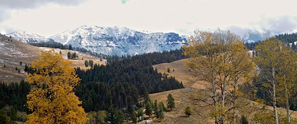
Gorgeous views of rolling meadows and towering peaks(photo by Sylvia Davis)
Dailey Creek to Teepee Creek (near Yellowstone National Park)
This moderately trafficked trail will take you through sagebrush meadows with views of the Gallatin and Madison ranges. From Dailey Creek, you’ll head to Teepee Creek in the Hyalite Porcupine Buffalo Horn Wilderness Study Area, an area addressed in the Custer-Gallatin National Forest Plan revision. Beginning hikers, families, and anyone who loves wild solitude will enjoy this pleasant adventure.
– Emily Cleveland, senior field director
How to get there: Teepee Creek Trail #39
Roundtrip Distance: 6 mi.
Elevation Gain: 925 ft.
Highest Elevation: 7,600 ft.
Hike to the top of this iconic pyramid-shaped summit for a unique 360* view of the Missoula, Mission, and Bitterroot valleys. (photo by Bob Hopkins)
Cha-Paa-Qn Peak (near Missoula)
Cha-Paa-Qn (the Salish name meaning “shining peak,” pronounced “cha pa kwin”) is the peak on Missoula’s western horizon with a nearly perfectly triangular top. I suspect that most of Missoula’s residents take note of Cha-Paa-Qn almost daily, and most of the year it shows off a snowy hat. It’s uniquely satisfying to hike to the top of a peak you gaze at from a distance so frequently.
Cha-Paa-Qn is accessed via the Nine Mile Valley on a fairly well-maintained Forest Service road. In the fall the road is flanked by golden larch, and western red cedar cling to one of the road’s tightest turns year-round. The first two miles of trail are in the forest. It’s a rooty, steady climb to start, but the deep forest makes it pleasant even on hot days. After mile two, the trail opens out into a few alpine meadows with views back towards Missoula. The last quarter mile is not really a trail but a fun, fairly strenuous scramble over large rocks to gain the summit. From the top you’ll take in 360-degree views toward the Mission Mountains, back over the Missoula Valley, west toward the Great Burn, and south along the Bitterroot Range. It’s a stunning view and one you’ll enjoy revisiting in your mind every time you gaze toward Cha-Paa-Qn Peak when you’re back on the valley floor.
– Erin Clark, western Montana field director
Getting there: Explore Ch-paa-qn Peak, Trail #98
Roundtrip Distance: 7 mi.
Elevation Gain: 1,200 ft.
Highest Elevation: 7,996 ft.
A moderate hike featuring wildflowers and wildlife (photo by Dee Kerry Neils)
The Crown Mountain Trail (Bob Marshall Wilderness)
Most times when people think of The Bob, their minds jump directly to The Chinese Wall, with its soaring reef and long approach. There’s another reef worth mentioning, though, that’s seldom visited and has one of my favorite campsites in The Bob: The Crown Mountain Trail, aka The Scapegoat Loop. It’s a 30-mile, multi-day cherry-stem that starts with a quick summit over Crown Mountain Pass, then drops down into a large, recently burned area. (In fact, about 80% of this hike is burned, so I’d highly recommend not hiking it in peak summer as my wife and I did.)
After descending the pass, the route briefly follows the CDT and then cuts south along the Green Fork. It’s here that you’ll have the opportunity to drop your packs and head up to Scapegoat Mountain if you have the energy; if not, head down into Halfmoon Park, a campsite ringed on one side by a massive reef with easy access to water and shade. You’ll then have the option to follow three separate drainages to finish the loop around Halfmoon Peak to the CDT and back up to Crown Mountain Pass. This is a somewhat strenuous hike through a burn area with little shade, but the opportunity to camp a night at Halfmoon Park beneath the soaring reef is definitely worth it. And while you’re out there, be sure to say hi to the ranger at the Green Fork Guard Station!
– Mike Rooney, development manager
Getting there: Explore the Crown Mountain Trail
Roundtrip Distance: 8.8 mi.
Elevation Gain: 3,067 ft.
Highest Elevation: 8,340 ft.
Continental Divide
The wild place I turn to, again and again, is the Continental Divide. There is a hike, ski, or snowshoe for each season. Flesher Pass offers a choice of two wildlands. South of Flesher Pass, the Continental Divide National Scenic Trail (CDT) enters the Specimen Creek Roadless Conservation Area. Continue south all the way (11 miles) to Stemple Pass.
To the north, the CDT ascends into the Anaconda Hill Roadless Conservation Area. From the very first overlook, you can look south and see Specimen Creek, Nevada Mountain, and – in the distance – the Electric Peak Roadless Conservation Areas along the winding Divide. North a turn reveals glimpses of massive Red Mountain (9400'), the highest peak of the Scapegoat, Bob Marshall and Great Bear Wilderness region. The face of Red Mountain – home to grizzlies, mountain goats, elk, and wolverines – is proposed for inclusion in the Scapegoat Wilderness. In summer, this reach of the CDT offers spectacular vistas of mountains and prairie all the way to Rogers Pass (13 miles). Be prepared for wind!
In spring, fall, and early summer, I am drawn to the crown jewel of this stretch of the Great Divide: the Nevada Mountain proposed Wilderness. There is something special about the way these mountains rise and roll unmarred by roads, and open up into intimate cirque basins along the headwaters of Little Prickly Pear. The Continental Divide National Scenic Trail follows the twisting rise of the Divide through excellent wildlife habitats. Watch for tracks of elk, moose, grizzly, lynx, or wolverine along the wild divide, and wildflowers!
– John Gatchell, senior conservation adviser
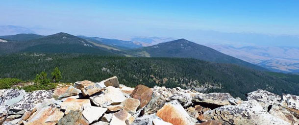
Baldy Mountain (near Butte)
Hiking Baldy Mountain (10568’) proves an excellent introduction to the East Pioneers, Montana’s fifth-highest range and one of the best in southwest Montana. Because of
a higher elevation approach, this hike/climb does not drain your battery and affords fabulous, 360-degree views. Most of the route is flagged, and once you’ve reached the saddle you veer left (west), upwards through thinning lodgepole. At treeline, a moderate switchback trail through the talus slopes winds up and just south of the false summit to the real one. From here, one sees into Idaho to the west, the Madison Range to the east, the Pintlers to the north, and the Beaverhead, Grasshopper, and Big Hole valleys. It presents an excellent picture of southwest Montana’s basin and range country. Pro tip: on the descent, don’t cut to the right (west) and avoid wandering below Black Mountain.
– Alan Weltzien, MWA Southwestern Wildlands Chapter volunteer
Getting there: Drive from either Badger Pass or the Argenta Flats Road to FS2400 (the Dyce Creek Road) and park at an elbow below the saddle between Black and Baldy Mountains.
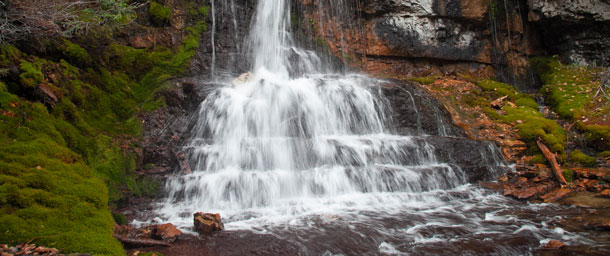
Crystal Cascades in the Big Snowy Mountains(photo by Nikki Yancey)
Crystal Cascades in the Big Snowies (near Great Falls)
After numerous hikes to the crest of the Big Snowies – leading hikes to the Ices Caves for MWA, friends, and family – I took the time last summer to hike a trail that I’d passed on the way to Crystal Lake. The Crystal Cascade Trailhead is about 2.5 miles before Crystal Lake and is well marked. When I pulled into the parking lot, there were a few other cars and one couple just starting their hike. As I headed up the trail, I encountered the couple I spotted earlier already on their way back. They were daunted by a stream crossing but, receiving a quick word of caution, I continued up the trail. Within 200 feet I encountered the first of many stream crossings (22 in total if I remember correctly). The trail travels about 3.5 miles and gains 1,000 feet to reach the Crystal Cascades, which is a beautiful 100-foot, stepped waterfall emerging from the mouth of a cave. If you’re looking for a longer trip, about a mile from the falls you can take a spur trail that connects to the Ice Cave trail. Apart from the first couple who quickly gave up, I had the trail entirely to myself.
– Zach Angstead, central Montana field director
Getting there: Explore Crystal Cascades Trail #445
Roundtrip Distance: 7 mi.
Elevation Gain: 770 ft.
Highest Elevation: 6,809 ft.
Mount Thompson-Seton, Whitefish Range
Up in northwest Montana, many of the trails in the Whitefish Range still have snow this time of year, but in the coming weeks, I highly recommend checking out the Mount Thompson-Seton trails.
Named for British author Ernest Thompson-Seton, this mountain is a joy to hike. After walking over the kelly hump at the end of Whale Creek Road, continue down the old roadbed (Whale Creek Trail #11) for a few hundred feet until you reach Inuya Creek. The creek can be a rushing torrent during spring run-off but becomes easier to cross on rocks as the water level drops during the summer. After crossing Inuya Creek, take the Inuya Creek Trail #79 to the right. This is easy to miss if you are not looking for it, as sometimes the trail sign is up and sometimes it isn’t.
After climbing for a mile or two, the vegetation thins and the trail parallels Inuya Creek rushing below. When you reach Inuya Pass, Trail #79 intersects with Trail #28, the Ninko-Thompson Seton Trail. The trail signage can be easy to miss, so I suggest familiarizing yourself with your map before heading out. Once you reach the summit, there are the remains of an old lookout. The views from the top are some of the best in the entire Whitefish Range and you can gaze at a sea of peaks in every direction. You’ll also see spectacular views into Canada and Glacier/Waterton National Parks and the Cabinet Mountains. Thompson-Seton is the second tallest peak in the Whitefish Range and it also provides an overview of the whole of the proposed wilderness that hopefully will encompass Tuchuck, Hefty, Review, Nasukoin, and Thompson-Seton.
– Allie Maloney, northwest Montana field director
Getting there: Explore Mount Thompson-Seton #79, #28
Roundtrip Distance: 11.2 mi.
Elevation Gain: 3,048 ft.
Highest Elevation: 7,820 ft.
As you’re discovering new trails on hikewildmontana.org, please consider donating to our trail stewardship program, which is making it possible for us to enjoy our public lands safely and conveniently. You can donate to support our trail crew here.
Keely Damara
Communications Coordinator
Keely provides communications support for our chapters, programs, and campaigns and manages our social media channels. In her free time, she enjoys fly fishing on Montana's scenic rivers, hiking, camping, and exploring public lands in her home state.
Email Keely
Related Posts
Stay Connected
"(Required)" indicates required fields